|
Oxbow Lakes
Oxbow lake is also a type of fluvial lakes, with its unique form drawing people's attention.
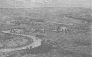
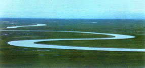
The rivers flowing on the plain develop the meander with time going on. They are becoming more and more curved while the flowing water erodes the riverbank. At last, the water flows into a new straight course and discards the original crooked course, which forms the lake. Because its shape resembles the yoke or crescent very much, the lake is also called oxbow or crescent lakes.
The forming process of a type of tectonic lakes-the rift lake is:
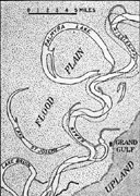
 the river swings and forms a crooked shape the river swings and forms a crooked shape
- the river erodes and corrodes the riverbank constantly, and the meander develops accordingly.
- the meander becomes more and more curved.
- the most crooked bank the river erodes and corrodes, and the river then takes its straight course.
- the river flows in the straight course and the original meander is discarded.
- the originally discarded course forms the oxbow lakeake.
 Chibakou Lake and originally existing Bailu Lake and Pai Lake of Hubei Province, as well as Ulansuhai Nur of Inter Mongolia Autonomous Region, all belong to the well-known oxbow lakes. Chibakou Lake and originally existing Bailu Lake and Pai Lake of Hubei Province, as well as Ulansuhai Nur of Inter Mongolia Autonomous Region, all belong to the well-known oxbow lakes.
Ulansuhai Nur is a translated name according to the Mongolian pronunciation, which means Poplar Lake. The lake lies 8.5km to the northeast of Wulate Front Banner of Bayannaoer League of the Inner Mongolia Autonomous Region and is a typical silted-river oxbow lake. The cause of formation of the lake is closely related with agricultural irrigation developed in the Hetao Plain after the Yellow River has changed its course.
1850 years ago, the Yellow River flew into the Hetao Plain and was divided into the southern and northern rivers. At that time, the southern river (nowadays the Yellow River) was still not the main river course. The northern river (nowadays between the Wula River and Wujia River) flowed along the Lang Mountain and converged with the Shimen River and then flew southward into the Southern River.
Later, the Hetao Plain sank because of the neotectonism, the northern river was blocked to the west of the Wula Mountains, and can not let out eastward. Therefore, there formed a curved river course, which was the predecessor of the Ulansuhai Nur.
Later, because of the increasingly expanded alluvial fans at the foot of Lang Mountains, the riverbed was raised and finally a section of river course with a length of 15.0km between the Wula River and the Wujia River was silted up. The northern river was forced to move southward, and became the Yellow River at present. In the original river course, only the two low-lying lands with accumulated water, Daba'erdong and Haihao, remained and formed the lakes with an area of only 2.0 km2 . The other lowlands are cultivated for the farmland.
After the peasants of the Han nationality settled down in the Hetao Plain, they treated the Wula River as a channel for retreating the water from the agricultural irrigation, which all flows into Daba'erdong and Haihao low-lying lands. In addition, the Yellow River overflows many times at that moment, and pours into the lakes, which are becoming larger and larger year by year. The present area of the lakes amounts to 233.0km2, with an utmost depth of 2.5m, an average depth of water of 1.12 m, and a water storage of 3.25x10⁸m3.
Fluvial Lakes <<
Barrier Lakes >>
|