|
The Deepest Lake-Tianchi Lake of Changbai Mountains
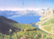
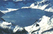
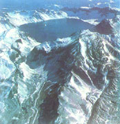 Tianchi Lake of Baitou Mountain gets another name called Tianchi of Changbai Mountains, and in the ancient time it is also named Youmen, Tumen, Wenliang, and Dragon Tan. Tumen in the Man nationality language means "ten thousand," and carries a meaning of the origin of rivers. It has an area of 9.82 km2 and an elevation 2194m. The maximum depth is 204m, and the water storage is 20.04x10⁸m3. The lake is the deepest lake and largest volcanic lake in China, which lies on the top of the Changpai Mountains in the Yanbian Prefecture of Jilin Province, on the border of China and North Korea. Mountains surround the lake, which was formed by the accumulated water in the crater that was already gone out. After numerous eruptions of the volcano, the crater expanded constantly and formed the typical volcanic lake. The recent eruptions happened in 1597, 1668, and 1702, and they are all explosive eruptions. The volcanic accumulation near the crater formed the towering conical mountain; around the crater there formed 16 mountains over 2500 meters high, among which the highest peak is Baitou Mountain, with an elevation of 2749.2m. A large amount of pumice burst forth and the volatile substances dissipated, which cause the crater to sink and form the funnel depression. Later the accumulated water in the depression evolved into the grand Tianchi Lake. Tianchi Lake of Baitou Mountain gets another name called Tianchi of Changbai Mountains, and in the ancient time it is also named Youmen, Tumen, Wenliang, and Dragon Tan. Tumen in the Man nationality language means "ten thousand," and carries a meaning of the origin of rivers. It has an area of 9.82 km2 and an elevation 2194m. The maximum depth is 204m, and the water storage is 20.04x10⁸m3. The lake is the deepest lake and largest volcanic lake in China, which lies on the top of the Changpai Mountains in the Yanbian Prefecture of Jilin Province, on the border of China and North Korea. Mountains surround the lake, which was formed by the accumulated water in the crater that was already gone out. After numerous eruptions of the volcano, the crater expanded constantly and formed the typical volcanic lake. The recent eruptions happened in 1597, 1668, and 1702, and they are all explosive eruptions. The volcanic accumulation near the crater formed the towering conical mountain; around the crater there formed 16 mountains over 2500 meters high, among which the highest peak is Baitou Mountain, with an elevation of 2749.2m. A large amount of pumice burst forth and the volatile substances dissipated, which cause the crater to sink and form the funnel depression. Later the accumulated water in the depression evolved into the grand Tianchi Lake.
The lake region belongs to the moist climate in the temperate zone, with an average annual temperature - 7. 4 C. The winter is 10 months long, and the period of snow accumulation can last 258 days. The vegetation in the lake region is distributed in a vertical belt: the vegetation is mainly Yuehua woods under the elevation of 2000m; high mountain tundra, Stone Flower, cuckoo are the main vegetation between 2000-2500m; above 2500m, the plant are sparse, short and small low-grade moss presenting a spot distribution, or the rocks on the earth's surface are exposed, including pumice, obsidian, trachyte, agglomerate, tuff as well as volcano gravel.
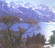
The lake water mainly depends on the precipitation above the lake surface for replenishment, and is supplemented with some underground springs. The catchment area is 21.41m2 and the coefficient of replenishment is 2.18. The water of Tianchi Lake lets out perennially, even after the lake freeze-ups in the winter, when the lake water can still flow out in the form of underflow , and reach the Chengcha River, forming the Changbai waterfall with a fall of 68m. Then the river pours down into the Erdaobai River, and becomes the headstream of the Second Songhua River. The lake water is azure and limpid, with a maximum transparency of 5.2m. The lake freeze-up from November to mid-June of next year lasts about 200 days. The mineralization degree of the lake water is 247mg/L, belonging to high mountain freshwater lake. The water type falls into the Typel I of Natrium Class of bicarbonate. The trophic state is mesotrophic and there is no fish living in the lake. The lake region is full of hot springs, the largest of which appeared under the Astronomical Peak, with a width of 30-40 m, length of 150m, water temperature of 42 C. In the district, the Changbai Mountain is a picturesque place where the mountains and rivers are like a painting. You can see the grotesque peaks and different valleys, the Milk Way hung by the feet, gurgling hot springs, white rip current surging forward and roaring, and boundless and indistinct sea of woods. There grow precious crude herbs like ginseng and hide numerous rare birds and animals in the forest, where is a charmed tourist attraction for people.
The Longest Lake--Jade Banggong Lake <<
The Highest Degree of Mineralization-Chaerhan Salt Lake >>
|